Ahora rentando apartamentos de 2 habitaciones • Excelente ubicación • Vida asequible
Ahead of the storm’s arrival this weekend, 11Alive will track updates throughout the day.
ATLANTA — Georgia and much of the Southeast are bracing for a winter storm this weekend that could bring substantial and disruptive freezing rain and ice accumulation.
While there is still uncertainty about the types of precipitation, we anticipate a long-duration wintry mix evolving over north Georgia that will last for most of the weekend. Winter Precipitation would start Saturday during the day and continue through at least Sunday evening.
Potential disruptions could include impassable roads, widespread power outages, and closures ranging from businesses that can’t open to schools keeping kids home into next week.
Ahead of the storm’s arrival this weekend, 11Alive will track updates throughout the day.
Ice storm warning expands
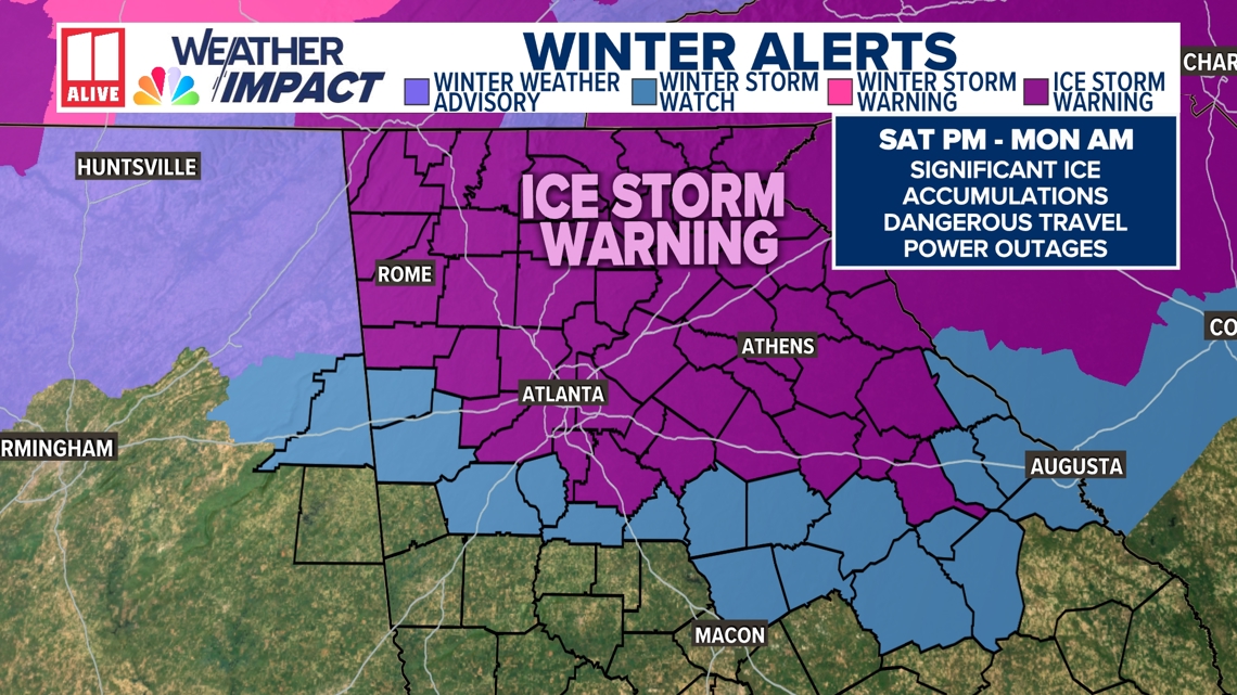
The National Weather Service has included the following counties into the ice storm warning: Rabun, Habersham, Stephens, Franklin, Hart, Elbert, Dawson, Lumpkin, White, Forsyth, Hall, Banks, Jackson, Madison, Pickens, Bartow, Cherokee, Polk, Paulding, Cobb, Fulton, Gwinnett, Barrow, Clarke, Oconee, Oglethorpe, Wilkes, Douglas, DeKalb, Rockdale, Walton, Newton, Morgan, Greene, Taliaferro, Clayton, Henry, Warren, Murray, Fannin, Gilmer, Union, Towns, Gordon, Floyd, Dade, Walker, Catoosa, Whitfield, and Chattooga.

Airport using new equipment to clear runways
Crews at Atlanta’s Hartsfield-Jackson International Airport will, for the first time, use new ice-clearing equipment to keep runways open as an expected ice storm hits the area.
A Winter Ice Warning has been issued for the Atlanta metro area, and the forecast currently calls for 1/4 to 1/2 inch of ice to form between Saturday afternoon and Sunday evening.
Despite that, officials at the world’s busiest airport believe planes will be able to take off and land over the weekend.
Will schools be closed on Monday?
As a potentially strong winter storm makes its way toward Georgia and across the entire Southeast, some schools in metro Atlanta and the northern part of the state are starting to react accordingly.
The disruptive winter storm could bring substantial freezing rain and damaging ice accumulations in parts of north Georgia and even some parts of metro Atlanta.
From possible impassable roads, widespread power outages due to ice, and a long-duration wintry mix, schools are being forced to close operations for certain days. Fortunately for school operations, this storm will likely impact most of the weekend, but it could have some impacts on Monday as well.
DeKalb County winter storm updates
Officials issued a state of emergency on Friday to mobilize county resources ahead of winter weather this weekend. This emergency response is closing all government buildings this weekend and cancelling events, including county-sponsored programs, officials said. According to officials, this includes recreation centers, libraries, and non-essential in-person services. Officials are urging residents to avoid getting on the roads unless necessary. The county has also opened warming centers throughout the county.
Residents can find more information at www.dekalbcountyga.gov. Officials said this website, along with their social media pages, will be updated as things change.
“We are operating with a coordinated county-wide effort,” said county CEO Lorraine Cochran-Johnson. “I want to be very clear: if you do not need to be on the roads, stay home.”
Cobb County winter storm updates
Officials urged residents to avoid travel when roads become slick, both for their safety and to give crews the best opportunity to stay ahead of deteriorating conditions. Precipitation is expected to start on Saturday midday and conditions will likely become worse into Saturday evening and Sunday morning.
Residents are encouraged to prepare for the weather event by:
- Completing any necessary preparations before the weekend
- Canceling or adjusting weekend plans to avoid travel
- Ensuring they have access to alerting devices, including options that will function during power outages.
Residents can also download the county’s CobbGov app to receive notifications about closures and other critical updates.
Gwinnett County issues emergency order
The Gwinnett County Office of Emergency Management is monitoring forecasts and coordinating with departments to prepare for the storm, including brining roads, checking generators at County facilities and making plans to ensure 24/7 staffing.
Residents are encouraged to prepare their homes and families:
•Keep flashlights and batteries on hand
• Use generators safely outdoors and away from doors and windows
• Make sure you have enough food, water, medications, and pet essentials
• Charge devices and backup power sources
• Protect your pipes from extreme cold by dripping faucets and opening cabinet doors
• Plan to stay off the roads unless necessary
“Declaring a local state of emergency gives us the flexibility and authority to respond quickly as conditions evolve, with the safety and well-being of our community as our top priority,” said Chairwoman Nicole Love Hendrickson.
Mayor Andre Dickens explains how the city is prepping for this weekend
City of Atlanta officials are working to prepare for the ice that is expected to impact metro Atlanta this weekend. Mayor Dickens is encouraging residents not to take unnecessary trips. Churches are also encouraged to hold virtual church services. Mayor Dickens said Atlanta DOT and GDOT trucks are expected to be on the roads on Saturday afternoon, along with Georgia Power.
“We’re just telling people be prepared have batteries, have flashlights, have food and water that can last you a couple of days as we wait out this ice event,” said Dickens.
MARTA scaling back on service starting Saturday
Starting at 6 a.m. Saturday, trains will run every 20 minutes, while the agency is scaling back on bus service.
- Red Line will operate from North Springs to Lindbergh Center Stations.
- Gold Line will operate from Doraville to Airport Stations.
- Green Line will operate from Bankhead to Vine City Stations.
- Blue Line will operate from Indian Creek to H.E. Holmes Stations.
- Service will begin at 8:21 a.m. on a regular Saturday schedule with shuttle vans.
The following bus routes will begin operating in the 5 a.m. hour at the frequency listed. These lifeline routes provide direct service to major medical facilities and emergency rooms. All other bus routes are suspended.
- Route 6 – Clifton Road/Emory – 45 minutes
- Route 8 – North Druid Hills – 30 minutes
- Route 19 – Clairmont/W. Howard Avenue – 40 minutes
- Route 40 – Peachtree Street/Downtown – 45 minutes
- Route 107 – Glenwood – 30 minutes
- Route 110 – Peachtree Road/Buckhead – 20 minutes
- Route 111 – Snapfinger Woods – 40 minutes
- Route 123 – Church Street – 60 minutes
- Route 185 – Alpharetta – 40 minutes
- Route 196 – Upper Riverdale – 30 minutes
How can I get the latest information on the winter storm?
A major winter storm that could bring severe disruption to metro Atlanta and north Georgia is on the way, and 11Alive is planning to cover developments as they happen throughout the weekend.
The best way to find our streaming coverage is through our smart TV app, 11Alive+.
What are the best-and worst-case scenarios?
We’re now less than 24 hours out from the start of this weekend’s Winter Storm Event in the southeast. There is still uncertainty in the extent of freezing rain expected across north Georgia.
Why? Some longer-range models are showing the wedge erode away quicker, while others keep the wedge stronger. This will become clearer as high-resolution models come within view and the event begins to our west. In many cases, the wedge can hold stronger than models suggest.
💌 Mantente al Día con lo Último del Entretenimiento Latino
Recibe noticias exclusivas de celebridades latinas, chismes virales, belleza, moda y entretenimiento — directo en tu correo.
Sin spam. Solo lo mejor de Atlanta Latinos Magazine.