Ahora rentando apartamentos de 2 habitaciones • Excelente ubicación • Vida asequible
Snow, ice and freezing rain from Texas to the Carolinas starting Friday.
ATLANTA — The ingredients are aligning for the first major winter storm of 2026. The massive system is expected to bring rain, snow, freezing rain and sleet from Texas across the Deep South into the Mid-Atlantic starting Friday and lasting through Sunday.
“Step one in the ingredients coming together is actually this really, really cold Arctic air mass — subzero temperatures coming into the upper Midwest,” said Owen Shieh, a warning coordination meteorologist with NOAA’s Weather Prediction Center. “As that comes down, the front side of that cold air will set up a cold front that drapes across the southern Plains into the Mississippi Valley and into the Southeast.”
Shieh says that cold air, combined with an area of low pressure drawing moisture from the Gulf, sets the stage for a potentially dangerous storm.
“There’s a large population that’ll be impacted,” Shieh said. “We’ll actually have more than 200 million Americans affected by temperatures below 20 degrees Fahrenheit. It’s a very large swath of the country that will have very cold temperatures, and on top of that, everywhere from Texas to the Carolinas is likely to see some sort of freezing precipitation impacts.”

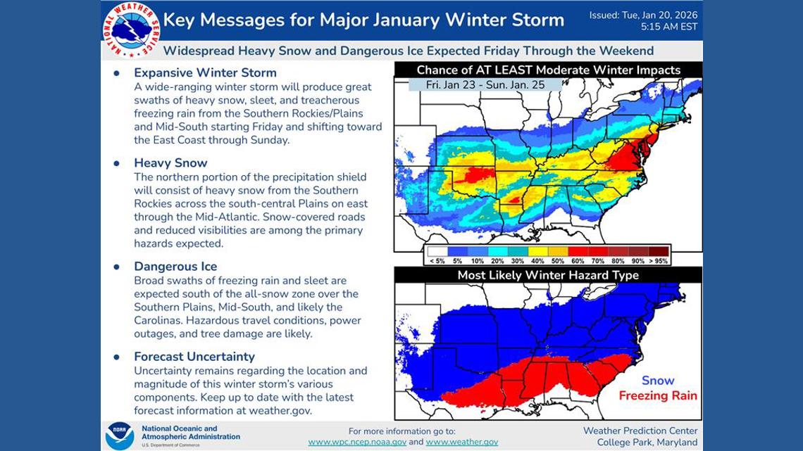
One of the greatest concerns is significant icing along Interstates 20 and 40 from Dallas to Atlanta and into the Carolinas, which could make travel impossible and trigger widespread power outages.
“I like to think of it as, it just so happens that the I-40 corridor is where we’re expecting more of the snow impacts, and the I-20 corridor just south of there is where we’re expecting most of the freezing rain,” Shieh said.
Shieh says impacts will start early Friday in Oklahoma and West Texas and then spread east over the weekend. NOAA notes there are still some model differences that could affect where the snow sets up on the northern edge of the storm, as well as where the ice develops. At this point, snow appears likely from North Texas through the Mid-South and into the Mid-Atlantic.
“We are seeing the computer model guidance giving us more confidence — a 70 to 80% chance — that most of the swath will get more than 4 inches of snow,” Shieh said. “There will be isolated areas where they get over a foot. It’s still too early to pinpoint where that might be, but confidence is increasing. And on the ice side, about a quarter inch of ice accumulation for a good portion of the swath looks pretty likely.”
Another factor that could make this a Southern storm for the history books is the likelihood that cold air will linger well after the precipitation ends. In Atlanta, for example, morning lows are expected to be in the 20s over the weekend and into Monday. The prolonged cold could allow slick spots to persist and pose a danger to people without power.
Right now, Shieh says it’s not the time to panic — but to prepare.
“I would encourage everyone to stay tuned to their local Weather Service forecast office,” he said. “If a watch or warning is issued, take precautions and take action according to local authorities.”
MORE WEATHER RESOURCES:
💌 Mantente al Día con lo Último del Entretenimiento Latino
Recibe noticias exclusivas de celebridades latinas, chismes virales, belleza, moda y entretenimiento — directo en tu correo.
Sin spam. Solo lo mejor de Atlanta Latinos Magazine.